 FormaTerre
Type of resources
Available actions
Topics
INSPIRE themes
Keywords
Contact for the resource
Provided by
Years
Formats
Representation types
Update frequencies
status
Scale
-
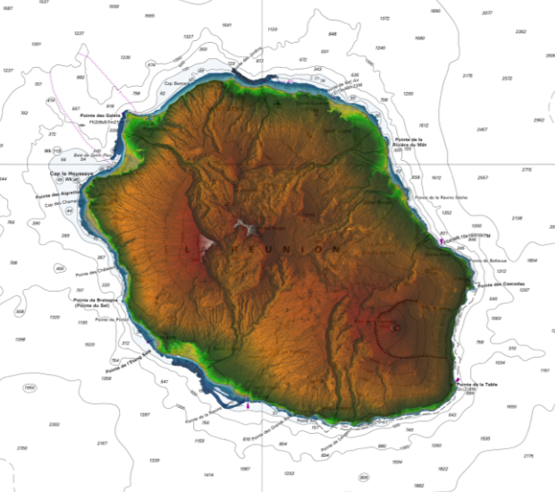
Litto3D is a unique and continuous land-sea database which can provide 3D models of the shape and location of French coastal terrain. A line separates sea and land data acquisition zones, and the associated survey readings obtained using bathymetric lidar technologies or multibeam echosounders for sea readings and airborne lidar topographical surveys for land readings, with 300 m overlap. Litto3D digital models are available in two formats: a set of 3D points and a qualified terrain mesh.
-

Bathymetric datasets are an extraction of surveys belonging to the Shom public database. For depth up to 50m, the vertical precision of soundings varies from 30cm to 1m and the horizontal precision varies from 1 to 20m. In deep ocean, the vertical precision is mainly around 1 or 2% of the bottom depth. It is sometimes more, it depends on the technology used. The data are referenced to ZH which is assimilated to LAT. Data are corrected for sound velocity variations. <br /> October 27 2025 version
-
Hydraulic data recorded at GPK3 (https://cdgp.u-strasbg.fr/geonetwork/srv/fre/catalog.search#/metadata/SSF-GPK3), GPK2 (https://cdgp.u-strasbg.fr/geonetwork/srv/fre/catalog.search#/metadata/SSF-GPK2), GPK1 (https://cdgp.u-strasbg.fr/geonetwork/srv/fre/catalog.search#/metadata/SSF-GPK1) and EPS1 (https://cdgp.u-strasbg.fr/geonetwork/srv/fre/catalog.search#/metadata/SSF-EPS1). Two datasets are available: SSFS2003-Hydraulic_stimulation.csv: hydraulic data from 27/05/2003 to 23/06/2003. SSFS2003-Hydraulic_circulation.csv: hydraulic data from 23/06/2003 to 22/08/2003. The first dataset corresponds to the stimulation of GPK3. The second dataset corresponds to the data recorded during the circulation test between GPK3 and GPK2, with GPK3 as injection well and GPK2 as production well. The data parameters are the following: Qin_GPK3: GPK3 injection flowrate Qin_GPK2: GPK2 injection flowrate Tw1_GPK3: GPK3 wellhead temperature Tw1_GPK2: GPK2 wellhead temperature Tw2_GPK2: GPK2 wellhead temperature (other sensor) Pw1_GPK3: GPK3 wellhead pressure Pw2_GPK3: GPK3 wellhead pressure (other sensor) Pa1_GPK3: GPK3 annulus pressure Pw1_GPK2: GPK2 wellhead pressure Pw2_GPK2: GPK2 wellhead pressure (other sensor) Pa1_EPS1: EPS1 annulus pressure Qex1_GPK2: GPK2 production flowrate Pa1_GPK2: GPK2 annulus pressure Pwc_GPK1: GPK1 wellhead pressure Last update of data: 22/02/2022
-
In order to improve the seismic monitoring of the Soultz-sous-Forêts geothermal site, a new seismic observation well was drilled in 2000. After two months of drilling, OPS4 reached the final depth of 1537m. Location of the OPS4 wellhead (in WGS84): - Latitude: 48.92108705 | 48° 55' 15" N - Longitude: 7.88306364 | 7° 52' 59" E - Altitude: 204m
-
Hydraulic data recorded at GPK2 (https://cdgp.u-strasbg.fr/geonetwork/srv/fre/catalog.search#/metadata/SSF-GPK2), GPK1 (https://cdgp.u-strasbg.fr/geonetwork/srv/fre/catalog.search#/metadata/SSF-GPK1) and EPS1 (https://cdgp.u-strasbg.fr/geonetwork/srv/fre/catalog.search#/metadata/SSF-EPS1). Two datasets are available: SSFS2000-Hydraulic_stimulation.csv: hydraulic data from 30/06/2000 to 13/07/2000. SSFS2000-Hydraulic_injection_test.csv: hydraulic data from 13/07/2000 to 20/07/2000. The first dataset corresponds to the data collected during the stimulation phase of GPK2. The second dataset corresponds to the data recorded during the post-stimulation injection test realized at GPK2. The data parameters are the following: Qin1: GPK2 injection flowrate with Omega/Ebara pump Qin2: GPK2 injection flowrate with ERGA pump Tin: GPK2 injection temperature Pw1: GPK2 wellhead pressure (400 bar sensor) Pw2: GPK2 wellhead pressure (200 bar sensor) Pa: GPK2 annulus pressure Pa_EPS1: EPS1 annulus pressure Qin3: GPK2 injection flowrate with BGR pump Qin4: ? Pwc_GPK1: GPK1 pressure above water column Pa_GPK1: GPK1 annulus pressure Qin_total: GPK2 total injection flowrate WL_GPK1: GPK1 water level Pw3: GPK2 wellhead pressure (50 bar sensor) Last update of data: 06/09/2019
-
3D velocity model of the Upper Rhine Graben, from Lengliné et al. (2023). Grids are +/-100km in X and Y directions around LatOrig=48.661660 and LongOrig=7.773860, (401 points @ 500m between points), and 0-50km in depth (101 points @ 500m). Data are in NonLinLoc (https://github.com/alomax/NonLinLoc) format.
-
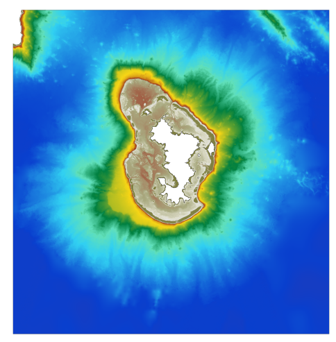
The bathymetric DEM for the coasts of Mayotte with a resolution of 0.001° (~ 100 m) was prepared as part of the HOMONIM project. It covers the entire island of Mayotte and extends to Anjouan island in the west. The model ranges off-shore to a depth of 3700 m. The DEM is designed to be used in hydrodynamic models in order to produce high-precision forecasts for coastal water levels and sea conditions and therefore improve the pertinence of the Waves-Submersion monitoring programme. This product is available with the Lowest Astronomic Tide (LAT) or the Mean Sea Level (MSL) as a vertical datum.
-
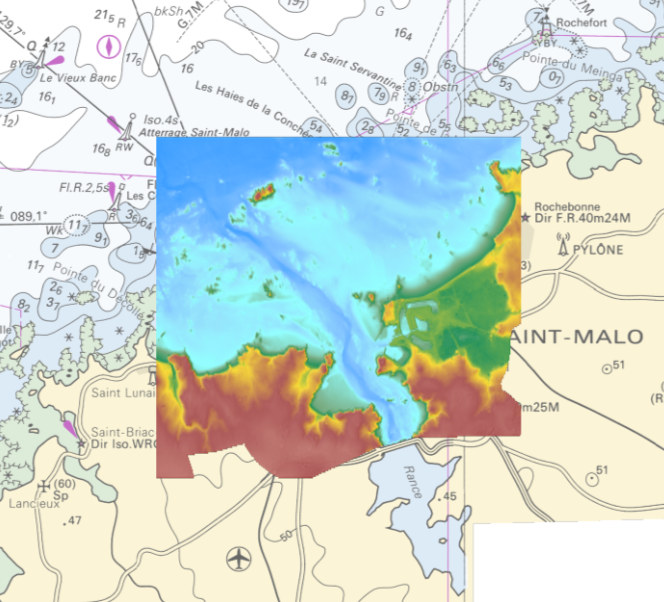
The coastal topo- bathymetric DEM of the port of Saint-Malo and its surroundings with a resolution of 0.00005° (~ 5 m) was prepared as part of the PAPI Saint-Malo. It covers the city of Saint-Malo and its surroundings, from the tip of Décollé in the west to the tip of Varde in the east. The DEM is designed to be implemented in the hydrodynamic models of the TANDEM project in order to estimate the coastal effects of tsunamis for the Atlantic and English Channel, where French nuclear power plants have been installed for about 30 years. This product is available with the Lowest Astronomic Tide (LAT) or the Mean Sea Level (MSL) as a vertical datum.
-
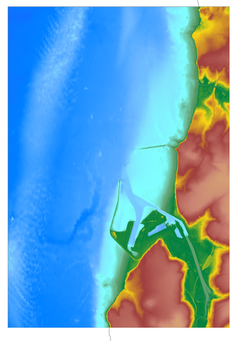
The coastal topo- bathymetric DEM for the coasts of Boulogne-Sur-Mer with a resolution of 0.0001° (~ 10 m) was prepared as part of the TANDEM project (Programme Investissements d'Avenir, ANR-11-RSNR-00023-01). The DEM covers the entire Boulogne-sur-Mer port, from north of Wimereux to south of the Boulogne-sur-Mer urban sprawl. The DEM is designed to be implemented in the hydrodynamic models of the TANDEM project in order to estimate the coastal effects of tsunamis for the Atlantic and English Channel, where French nuclear power plants have been installed for about 30 years. This product is available with the Lowest Astronomic Tide (LAT) or the Mean Sea Level (MSL) as a vertical datum.