 FormaTerre
CNES
Type of resources
Topics
Keywords
Contact for the resource
Provided by
Formats
Representation types
Update frequencies
status
-
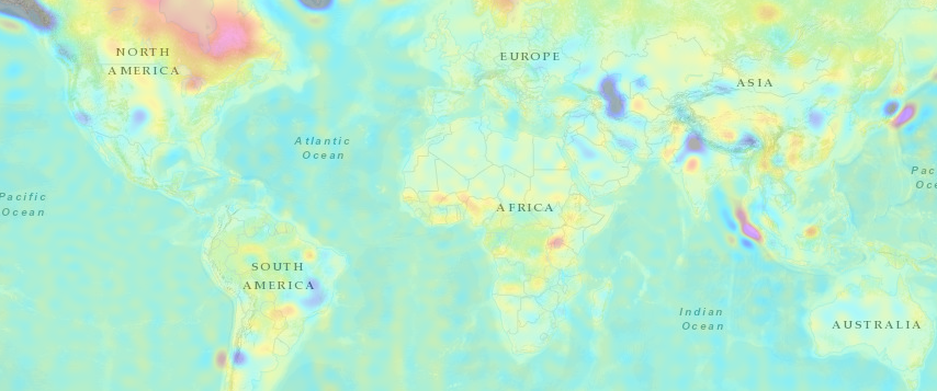
The GRACE level-2 products are the main outputs from the GRACE and GRACE-FO missions. They consist of the time average (10-day, monthly) solutions of the Earth gravity field in spherical harmonics. GRACE is a joint project between the National Aeronautics and Space Administration ( NASA ) and the Deutsches Zentrum für Luft- und Raumfahrt ( DLR ). The mission has been proposed in 1996 jointly by the University of Texas at Austin, Center for Space Research ( UTCSR ), the German Research Centre for Geosciences ( GFZ ) and the Jet Propulsion Laboratories (JPL) in Pasadena. GRACE was selected in 1997 as second mission in NASA's Earth System Science Pathfinder ( ESSP ) program. As an innovation, the Principal Investigator Prof. Byron Tapley (UTCSR) and his team are ultimately responsible for developing the flight mission hardware from selection to a launch-ready condition, for accomplishing the scientific objectives and delivering the proposed measurements to the broader Earth science community and general public as expediently as possible. Co-Principal Investigator of the mission is Dr. Frank Flechtner (GFZ). Project management and systems engineering activities are carried out by JPL. GRACE-FO is a joint project between the National Aeronautics and Space Administration ( NASA ) and the GeoForschungsZentrum ( GFZ ) Potsdam. GRACE-FO, launched May 22, 2018, is a successor to the original GRACE mission. The Principal Investigator at NASA JPL is Felix landerer. Co-Principal Investigator of the mission is Dr. Frank Flechtner (GFZ). Project management and systems engineering activities are carried out by JPL.
-
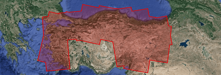
The objective of this project is to characterize the seismic and aseismic functioning of the North Anatolian and East Anatolian faults, in order to better assess their seismic hazard and understand the physical processes governing the dynamics of a fault. It also includes the monitoring of deformations in an area of grabens in western Turkey, major geological structures with high seismic potential. Three types of products are made available for each orbit portion processed (see <a href="https://formater.pages.in2p3.fr/flatsim/" target="_blank"> detailed description </a> ) - "INTERFEROGRAM": this brings together the differential interferograms, wound and unwound, in radar or terrain geometry, filtered or not, at different resolutions, as well as the atmospheric correction maps used and spatial coherence for each interferogram. - "TIMESERIES": this includes maps of movement in time series and average speed, according to the satellite line of sight (LOS), and quality indices of time series processing. - "AUXILIARYDATA": this directory contains maps indicating the LOS vector, the DTM in radar geometry, at different resolutions, the radar-field geometry transcoding tables, and temporal coherence, as well as a set of figures and parameter files specific to the processing of the time series.
-
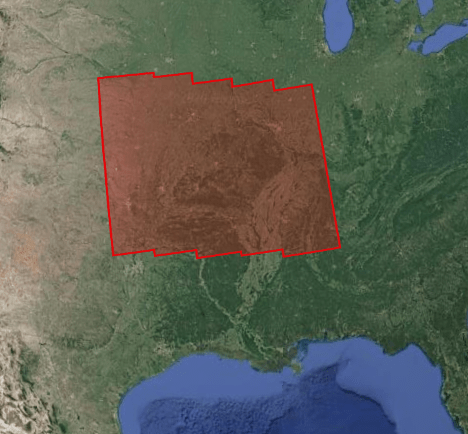
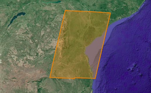
This project focuses on the study of the deformations associated with the Ozark aquifer (south of the Mississippi basin) subjected to strong variations in groundwater level, and in neighboring regions where significant seismicity is observed, at strong seasonal component (New Madrid), or linked to wastewater injections (Oklahoma). The objective is to better understand the geodesic signature of the hydrological cycle. Three types of products are made available for each orbit portion processed (see <a href="https://formater.pages.in2p3.fr/flatsim/" target="_blank"> detailed description </a> ) - "INTERFEROGRAM": this brings together the differential interferograms, wound and unwound, in radar or terrain geometry, filtered or not, at different resolutions, as well as the atmospheric correction maps used and spatial coherence for each interferogram. - "TIMESERIES": this includes maps of movement in time series and average speed, according to the satellite line of sight (LOS), and quality indices of time series processing. - "AUXILIARYDATA": this directory contains maps indicating the LOS vector, the DTM in radar geometry, at different resolutions, the radar-field geometry transcoding tables, and temporal coherence, as well as a set of figures and parameter files specific to the processing of the time series.
-
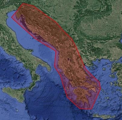
The Balkan region is one of the most seismic zones in Europe, with intense industrial and demographic development. This project aims to better quantify the deformations of tectonic origin in this region (kinematics and localization of active faults, study of earthquakes). He is also interested in deformations of anthropogenic or climatic origin (linked to the exploitation of natural resources or to variations in sea level) Three types of products are made available for each orbit portion processed (see <a href="https://formater.pages.in2p3.fr/flatsim/" target="_blank"> detailed description </a> ) - "INTERFEROGRAM": this brings together the differential interferograms, wound and unwound, in radar or terrain geometry, filtered or not, at different resolutions, as well as the atmospheric correction maps used and spatial coherence for each interferogram. - "TIMESERIES": this includes maps of movement in time series and average speed, according to the satellite line of sight (LOS), and quality indices of time series processing. - "AUXILIARYDATA": this directory contains maps indicating the LOS vector, the DTM in radar geometry, at different resolutions, the radar-field geometry transcoding tables, and temporal coherence, as well as a set of figures and parameter files specific to the processing of the time series.
-
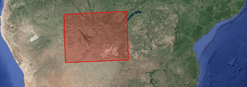
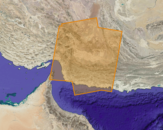
This project aims to better understand the deformations of tectonic origin in the area of the Okavango Delta (associated with the functioning of the Okavango rift and the East African rift), or of hydrological origin (linked in particular to the flood cycle. ), and the possible interactions between tectonics and hydrology in this region. Three types of products are made available for each orbit portion processed (see <a href="https://formater.pages.in2p3.fr/flatsim/" target="_blank"> detailed description </a> ) - "INTERFEROGRAM": this brings together the differential interferograms, wound and unwound, in radar or terrain geometry, filtered or not, at different resolutions, as well as the atmospheric correction maps used and spatial coherence for each interferogram. - "TIMESERIES": this includes maps of movement in time series and average speed, according to the satellite line of sight (LOS), and quality indices of time series processing. - "AUXILIARYDATA": this directory contains maps indicating the LOS vector, the DTM in radar geometry, at different resolutions, the radar-field geometry transcoding tables, and temporal coherence, as well as a set of figures and parameter files specific to the processing of the time series.
-
Three types of products are made available for each orbit portion processed (see <a href="https://formater.pages.in2p3.fr/flatsim/" target="_blank"> detailed description </a> ) - "INTERFEROGRAM": this brings together the differential interferograms, wound and unwound, in radar or terrain geometry, filtered or not, at different resolutions, as well as the atmospheric correction maps used and spatial coherence for each interferogram. - "TIMESERIES": this includes maps of movement in time series and average speed, according to the satellite line of sight (LOS), and quality indices of time series processing. - "AUXILIARYDATA": this directory contains maps indicating the LOS vector, the DTM in radar geometry, at different resolutions, the radar-field geometry transcoding tables, and temporal coherence, as well as a set of figures and parameter files specific to the processing of the time series.
-
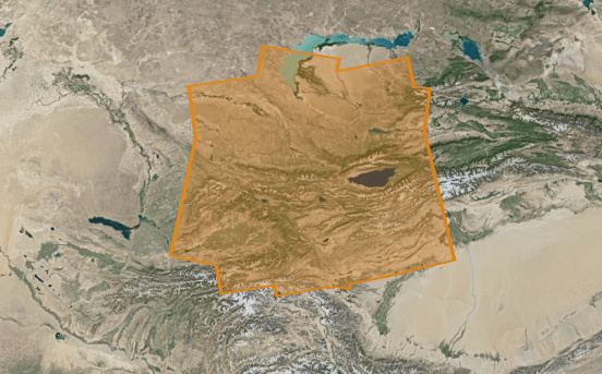
This project focuses on the analysis of tectonic deformations along the Western Kunlun Range, on the northwestern edge of the Tibetan Plateau. This region is marked by the interaction between large strike-slip and thrust faults, with in particular the existence of one of the largest thrust sheet in the world, whose interseismic loading and the capacity to produce “mega-earthquakes” will be investigated. Three types of products are made available for each orbit portion processed (see <a href="https://formater.pages.in2p3.fr/flatsim/" target="_blank"> detailed description </a> ) - "INTERFEROGRAM": this brings together the differential interferograms, wound and unwound, in radar or terrain geometry, filtered or not, at different resolutions, as well as the atmospheric correction maps used and spatial coherence for each interferogram. - "TIMESERIES": this includes maps of movement in time series and average speed, according to the satellite line of sight (LOS), and quality indices of time series processing. - "AUXILIARYDATA": this directory contains maps indicating the LOS vector, the DTM in radar geometry, at different resolutions, the radar-field geometry transcoding tables, and temporal coherence, as well as a set of figures and parameter files specific to the processing of the time series.
-
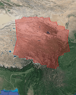
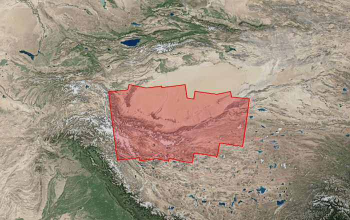
The objective of the project is to quantify and model the current deformations on the eastern edge of the Tibetan plateau. It focuses on deformations of tectonic origin, at the scale of active faults as well as at the continental scale, to address issues of the seismic cycle and uplift mechanisms of the Tibetan plateau. This project is also interested in non-tectonic signals present in time series (hydrological overloads in particular). Three types of products are made available for each orbit portion processed (see <a href="https://formater.pages.in2p3.fr/flatsim/" target="_blank"> detailed description </a> ) - "INTERFEROGRAM": this brings together the differential interferograms, wound and unwound, in radar or terrain geometry, filtered or not, at different resolutions, as well as the atmospheric correction maps used and spatial coherence for each interferogram. - "TIMESERIES": this includes maps of movement in time series and average speed, according to the satellite line of sight (LOS), and quality indices of time series processing. - "AUXILIARYDATA": this directory contains maps indicating the LOS vector, the DTM in radar geometry, at different resolutions, the radar-field geometry transcoding tables, and temporal coherence, as well as a set of figures and parameter files specific to the processing of the time series.
-
Three types of products are made available for each orbit portion processed (see <a href="https://formater.pages.in2p3.fr/flatsim/" target="_blank"> detailed description </a> ) - "INTERFEROGRAM": this brings together the differential interferograms, wound and unwound, in radar or terrain geometry, filtered or not, at different resolutions, as well as the atmospheric correction maps used and spatial coherence for each interferogram. - "TIMESERIES": this includes maps of movement in time series and average speed, according to the satellite line of sight (LOS), and quality indices of time series processing. - "AUXILIARYDATA": this directory contains maps indicating the LOS vector, the DTM in radar geometry, at different resolutions, the radar-field geometry transcoding tables, and temporal coherence, as well as a set of figures and parameter files specific to the processing of the time series.