Sentinel-1 Interferograms and time series collection on the Balkan region 2014-2021
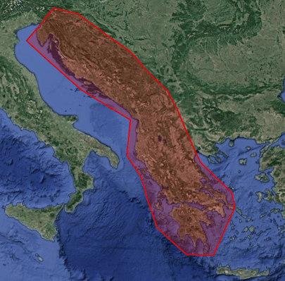
The Balkan region is one of the most seismic zones in Europe, with intense industrial and demographic development. This project aims to better quantify the deformations of tectonic origin in this region (kinematics and localization of active faults, study of earthquakes). He is also interested in deformations of anthropogenic or climatic origin (linked to the exploitation of natural resources or to variations in sea level)
Three types of products are made available for each orbit portion processed (see <a href=" https://formater.pages.in2p3.fr/flatsim/ " target="_blank"> detailed description </a> )
- "INTERFEROGRAM": this brings together the differential interferograms, wound and unwound, in radar or terrain geometry, filtered or not, at different resolutions, as well as the atmospheric correction maps used and spatial coherence for each interferogram.
- "TIMESERIES": this includes maps of movement in time series and average speed, according to the satellite line of sight (LOS), and quality indices of time series processing.
- "AUXILIARYDATA": this directory contains maps indicating the LOS vector, the DTM in radar geometry, at different resolutions, the radar-field geometry transcoding tables, and temporal coherence, as well as a set of figures and parameter files specific to the processing of the time series.
Simple
- Date (Revision)
- 2021-04-15
- Citation identifier
-
urn:ogc:def:EOP:CNES::BALKANS:
- Purpose
-
The Balkan region is one of the most seismic zones in Europe, with intense industrial and demographic development. This project aims to better quantify the deformations of tectonic origin in this region (kinematics and localization of active faults, study of earthquakes). He is also interested in deformations of anthropogenic or climatic origin (linked to the exploitation of natural resources or to variations in sea level)
- Status
- Completed
- Maintenance and update frequency
- As needed
- Theme
-
-
InSar
-
Deformation
-
interferogram
-
- location
-
-
Balkan region
-
- Access constraints
- Restricted
- Use constraints
- Other restrictions
- Use constraints
- License
- Other constraints
-
How to cite: "FormaTerre (2020): FLATSIM Data Products. CNES. (Dataset), doi: https://www.doi.org/10.24400/253171/FLATSIM2020 "
- Other constraints
- Other constraints
-
FAIR data, in validation phase, accessible only to the FormaTerre community
- Spatial representation type
- Grid
- Distance
- 320 m
- Language
-
eng
- Character set
- UTF8
- Topic category
-
- Geoscientific information
))
- Begin date
- 2014-10-01
- End date
- 2021-05-01
- Reference system identifier
- WGS 1984
- Distribution format
-
-
GEOTIFF
(
)
-
CSV
(
)
-
GEOTIFF
(
)
- OnLine resource
-
DOI 10.24400/253171/FLATSIM2020
(
DOI
)
Landing page produits FLATSIM doi:10.24400/253171/FLATSIM2020
- OnLine resource
-
Thollard & al. 2021
(
WWW:LINK-1.0-http--related
)
Thollard, F., Clesse, D., Doin, M.-P., Donadieu, J., Durand, P., Grandin, R., Lasserre, C., Laurent, C., Deschamps-Ostanciaux, E, Pathier, E., Pointal, E, Proy, C., Specht, B. (2021). FLATSIM: The FormaTerre LArge-Scale Multi-Temporal Sentinel-1 InterferoMetry Service, Remote Sens. 13 (18), 3734. doi:10.3390/rs13183734
- OnLine resource
-
Grandin. 2015
(
WWW:LINK-1.0-http--related
)
Grandin R. (2015). Interferometric Processing of SLC Sentinel-1 TOPS Data. In Proceedings of FRINGE’15: Advances in the Science and Applications of SAR Interferometry and Sentinel-1 InSAR Workshop, Frascati, Italy, 23-27 March 2015, ESA Publication SP-731. doi:10.5270/Fringe2015.116
- OnLine resource
-
Doin & al. 2011
(
WWW:LINK-1.0-http--related
)
Doin, M.-P., Lodge, F., Guillaso, S., Jolivet, R., Lasserre, C., Ducret, G., Grandin, R., Pathier, E., Pinel, V. (2011). Presentation of the small baseline NSBAS processing chain on a case example: The Etna deformation monitoring from 2003 to 2010 using Envisat data. In Proceedings of FRINGE 2011 ESA Workshop, Frascati, Italy,19–23 September 2011, ESA Publication SP-697.
- OnLine resource
- Product documentation ( WWW:LINK-1.0-http--samples )
- OnLine resource
-
API opensearch Flatsim
(
OpenSearch
)
search=free;view=FLATSIM_BALKANS_V;download=FLATSIM_BALKANS_VD
- Hierarchy level
- Series
Extent
- Statement
-
These collections of interferograms and displacement time series are produced by CNES as part of the FLATSIM service. This service is developed in collaboration with the ForM @ Ter Data and Services pole and the ISTerre, LGL-TPE and IPGP laboratories. The radar images used come from the TOPSAR Sentinel-1 archive (Copernicus data). The calculations are made from the NSBAS interferometric processing chain
- File identifier
- bf63b034-0fbc-40e4-af72-a254dc852cca XML
- Metadata language
- Français
- Character set
- UTF8
- Hierarchy level
- Series
- Date stamp
- 2024-05-03T10:37:27
- Metadata standard name
-
ISO 19115:2003/19139
- Metadata standard version
-
1.0
Overviews
Spatial extent
Provided by
