 FormaTerre
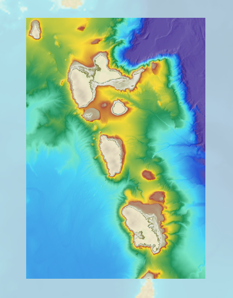
Bathymetric DEM for the coasts of Guadeloupe and Martinique (Homonim project)
The bathymetric DEM for the coasts of Guadeloupe and Martinique with a resolution of 0.001° (~ 100 m) was prepared as part of the HOMONIM project. The DEM covers some of the Lesser Antilles islands, from Montserrat in the north to Sainte-Lucie in the south. The model ranges off-shore to a depth of 5800 m.
The DEM is designed to be used in hydrodynamic models in order to produce high-precision forecasts for coastal water levels and sea conditions and therefore improve the pertinence of the Waves-Submersion monitoring programme.
Simple
- Date (Creation)
- 2015-09-09T00:00:00
- Citation identifier
- http://www.shom.fr/BATHYMETRIE/MNT_ANTS100m_HOMONIM_WGS84
- Presentation form
- Digital map
- Credit
-
©Shom
- Status
- On going
- Maintenance and update frequency
- Not planned
-
GEMET - INSPIRE themes, version 1.0
-
-
Elevation
-
- Theme
-
-
bathymetry
-
digital elevation model
-
Product
-
open data
-
- Place
-
-
Guadeloupe
-
Martinique
-
Antilles
-
- Discipline
-
-
Geophysic
-
- Use limitation
-
Data may be freely used providing that the source is mentioned as follows "Shom,2018. MNT bathymétrique de façade de la Guadeloupe et de la Martinique (Projet Homonim). http://dx.doi.org/10.17183/MNT_ANTS100m_HOMONIM_WGS84 "
- Use limitation
-
Do not use for navigation
- Use limitation
-
The product is distributed under an Opendata license (version 2.0, April 2017), defined by the Etalab mission.
- Use limitation
-
Do not use for navigation
- Access constraints
- License
- Use constraints
- Other restrictions
- Other constraints
-
Data may be freely used providing that the source is mentioned as follows "Shom,2018. MNT bathymétrique de façade de la Guadeloupe et de la Martinique (Projet Homonim). http://dx.doi.org/10.17183/MNT_ANTS100m_HOMONIM_WGS84 "
- Access constraints
- Other restrictions
- Other constraints
- No public access restrictions.
- Classification
- Unclassified
- Spatial representation type
- Grid
- Distance
- 0.001 dd
- Language
- Français
- Character set
- UTF8
- Topic category
-
- Elevation
))
Vertical extent
- Minimum value
- -5738
- Maximum value
- 46
Vertical CS
Vertical datum
Vertical extent
- Minimum value
- -5738
- Maximum value
- 46
Vertical CS
Vertical datum
- Reference system identifier
- EPSG / WGS 84 (EPSG:4326) / 7.9
- Number of dimensions
- 2
- Dimension name
- Row
- Dimension size
- 2001
- Resolution
- 0.001 dd
- Dimension name
- Column
- Dimension size
- 2801
- Resolution
- 0.001 dd
- Cell geometry
- Area
- Transformation parameter availability
- No
- Distribution format
-
-
ArcGis Grid
(
-
)
-
BAG
(
-
)
-
GLZ
(
-
)
-
GRD
(
-
)
-
ArcGis Grid
(
-
)
- OnLine resource
- Shom geoportal ( WWW:LINK-1.0-http--link )
- OnLine resource
-
MNT_ANTS100m_HOMONIM_4326_WMSR
(
OGC:WMS
)
Bathymetric DEM Guadeloupe and Martinique facade raster WMS
- OnLine resource
- Download service LAT ( WWW:DOWNLOAD-1.0-http--download )
- OnLine resource
- Download service MSL ( WWW:DOWNLOAD-1.0-http--download )
- OnLine resource
- Shom distribution space ( WWW:LINK-1.0-http--link )
- Hierarchy level
- Dataset
Conformance result
- Date (Publication)
- 2010-11-23
- Explanation
-
Information sur la conformité au règlement d'interopérabilité des séries et des services de données géographiques.
- Pass
- Yes
Conformance result
- Date (Publication)
- 2013-12-10
- Explanation
-
Information sur la conformité de la ressource à une spécification (INSPIRE).
- Pass
- Yes
- Statement
-
In addition to the Shom data, the surveys of external organisms have been exploited, the contributors of which are as follows: BSH, Communauté d’Agglomération du Centre de la Martinique, Grand Port Maritime de la Guadeloupe, Institut de Physique du Globe de Paris (DEPLUS Christine (1998) AGUADOMAR cruise, RV L'Atalante, http://dx.doi.org/10.17600/98010120 ;
DEPLUS Christine, BOUDON Georges (2002) CARAVAL cruise, RV L'Atalante, http://dx.doi.org/10.17600/2010030 ; FEUILLET Nathalie (2009) GWADASEIS cruise, RV Le Suroît, http://dx.doi.org/10.17600/9020020 ;
LAIGLE Mireille, LEBRUN Jean Frédéric, HIRN Alfred (2007) SISMANTILLES 2 cruise, RV L'Atalante, http://dx.doi.org/10.17600/7010020 ), National Centre for Environmental Information, National Oceanography Centre of Southampton,
Université des Antilles et de la Guyane (LEBRUN Jean Frédéric (2009) KASHALLOW 2 cruise, RV Le Suroît, http://dx.doi.org/10.17600/9020010 ), United Kingdom Hydrographic Office, Woods Hole Oceanographic Institution.
- Description
-
The main tasks involved in producing this range of solutions are based on 4 key aspects, each intended to reduce uncertainty for the DEM:
1) collecting, evaluating, pre-processing and selecting data from multiple sources after acquisition using survey systems from various eras;
2) homogenising the vertical and horizontal datums for data sets;
3) using interpolation algorithms suitable for a heterogeneous distribution and the variable density of data, and
4) evaluating and qualifying the final product and preparing documentation.
- File identifier
- MNT_ANTS100m_HOMONIM_WGS84.xml XML
- Metadata language
- Français
- Character set
- UTF8
- Hierarchy level
- Dataset
- Date stamp
- 2018-02-06T09:36:02
- Metadata standard name
-
ISO 19115:2003/19139
- Metadata standard version
-
1.0
Overviews
Spatial extent
Provided by
