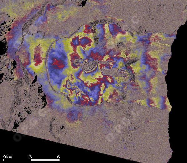
Base OI2 interférogramme Piton de la Fournaise
Piton de la Fournaise Interferogram Base OI2
Description Contenu BD
BD content description
Simple
-
Date (Revision)Date (Révision)
- 2021-04-15
-
Citation identifierIdentificateur
-
isdeform:reunion:interferogram
-
StatusEtat
-
On goingMise à jour continue
-
Maintenance and update frequencyFréquence de mise à jour
-
As neededLorsque nécessaire
-
ThemeThème
-
-
InSar
InSar
-
Déformation
Deformation
-
Interférogramme
interferogram
-
-
locationlocation
-
-
La Réunion
Réunion
-
-
Access constraintsContraintes d'accès
-
RestrictedRestreint
-
Use constraintsContraintes d'utilisation
-
Other restrictionsAutres restrictions
-
Autres contraintesOther constraints
-
Comment citer les produits:
How to cite:
-
Autres contraintesOther constraints
-
Les produits ne sont accessibles qu'aux utilisateurs enregistrés et authentifiés auprès de l'OPGC via un compte BASIC.
The products is only accessible to users registered and authenticated with OPGC via a BASIC account.
-
Spatial representation typeType de représentation spatiale
-
GridRaster
-
DistanceDistance de résolution
- 320 m
- Language
-
eng
-
Character setEncodage des caractères
-
UTF8Utf8
-
Topic categoryCatégorie ISO
-
-
Geoscientific informationSciences de la terre, géosciences
-
N
S
E
W
))
- Begin date
- 2003-04-01
-
Reference system identifierNom du système de référence
- WGS 1984WGS 1984
-
Distribution formatFormat (encodage)
-
-
TIFFGEOTIFF
(
)
-
CSVCSV
(
)
-
TIFFGEOTIFF
(
)
-
OnLine resourceRessource en ligne
- API opensearch OI2API opensearch Flatsim ( OpenSearch )
-
Hierarchy levelNiveau
-
SeriesCollection de données
Extent
Etendue
No information provided.
-
Généralités sur la provenanceStatement
-
Ces collections d'interférogrammes
These collections of interferograms
-
File identifierIdentifiant de la fiche
- 2e4a8a2a-a3b9-4921-9f46-1b3cd962d6fc XML
-
Metadata languageLangue
- Français
-
Character setJeu de caractères
-
UTF8Utf8
-
Hierarchy levelType de ressource
-
SeriesCollection de données
-
Date stampDate des métadonnées
- 2024-05-03T16:10:00
- Metadata standard name
-
ISO 19115:2003/19139
- Metadata standard version
-
1.0
Overviews
Spatial extent
N
S
E
W
Provided by

Associated resources
Not available