• Catalogue FormaTerre
  •   Rechercher
  •   Carte
  •  S'identifier

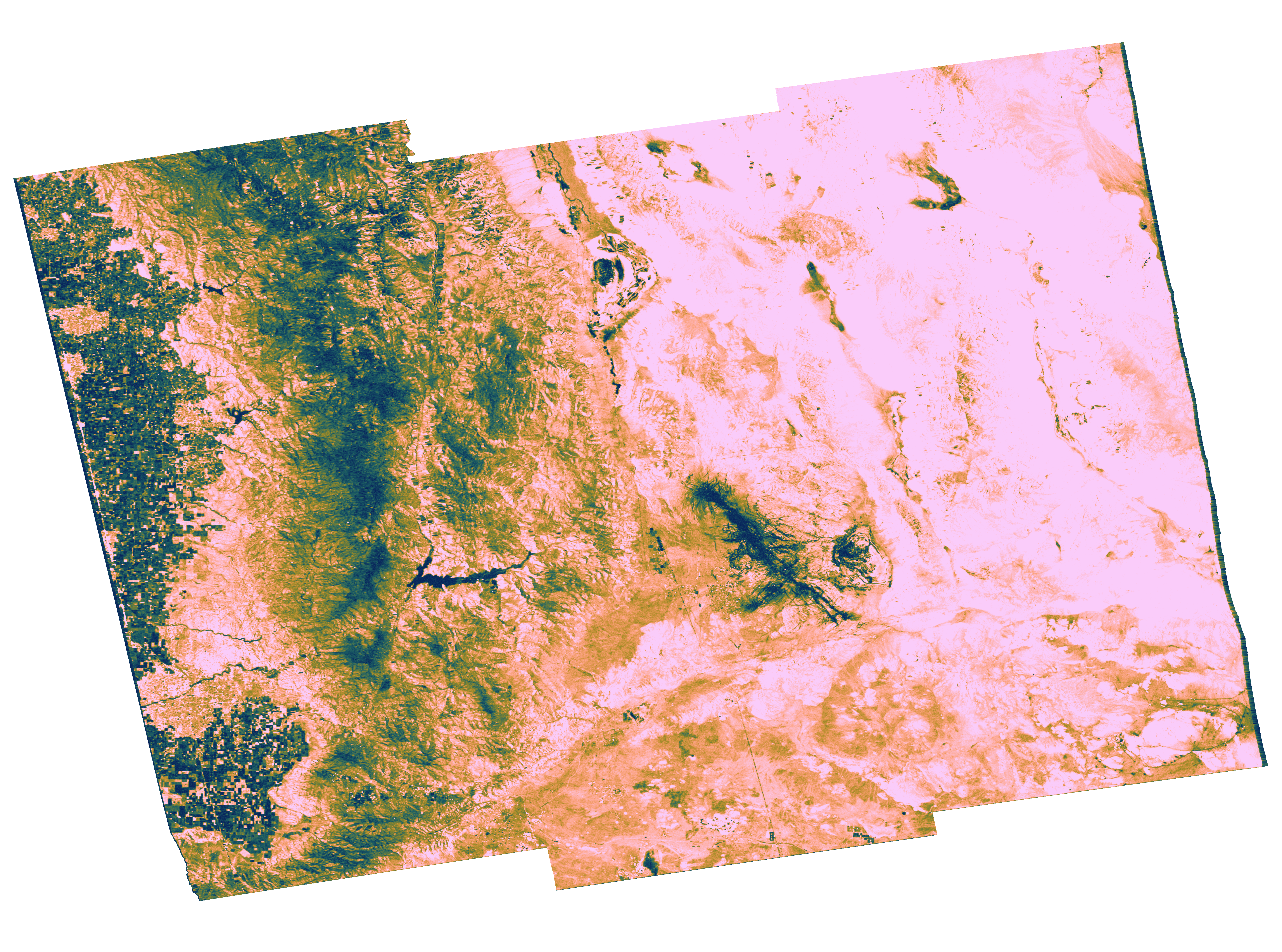
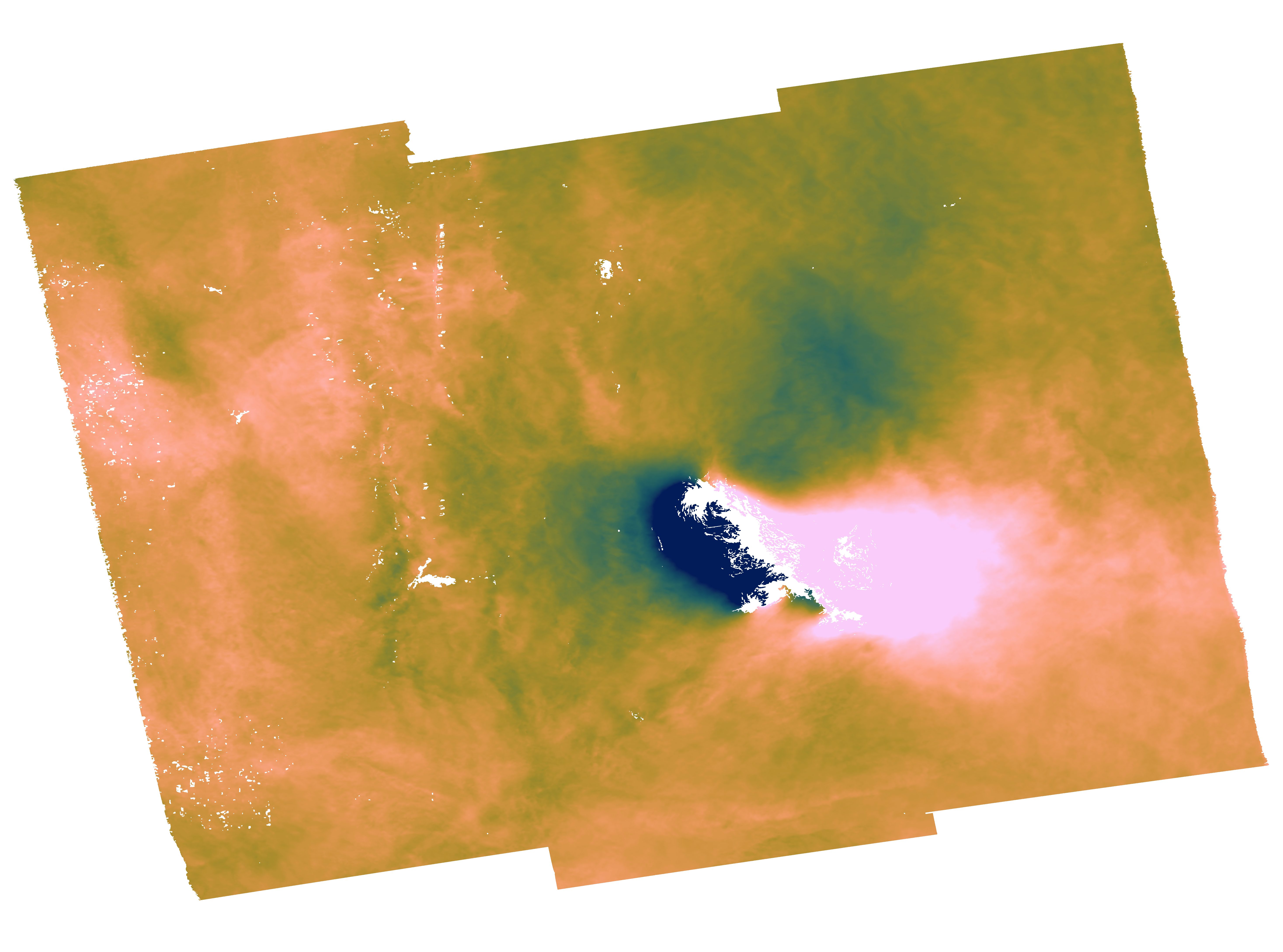
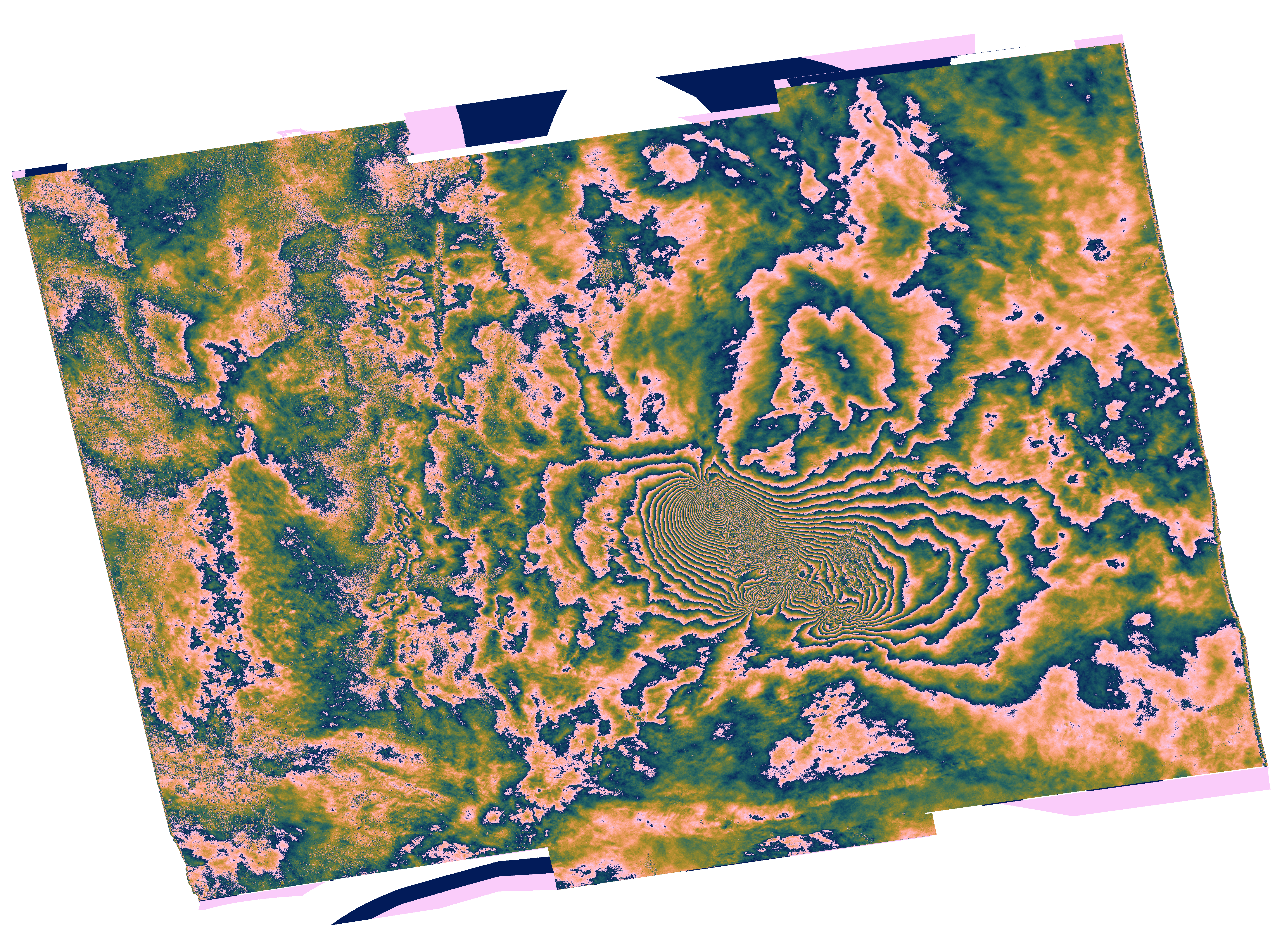
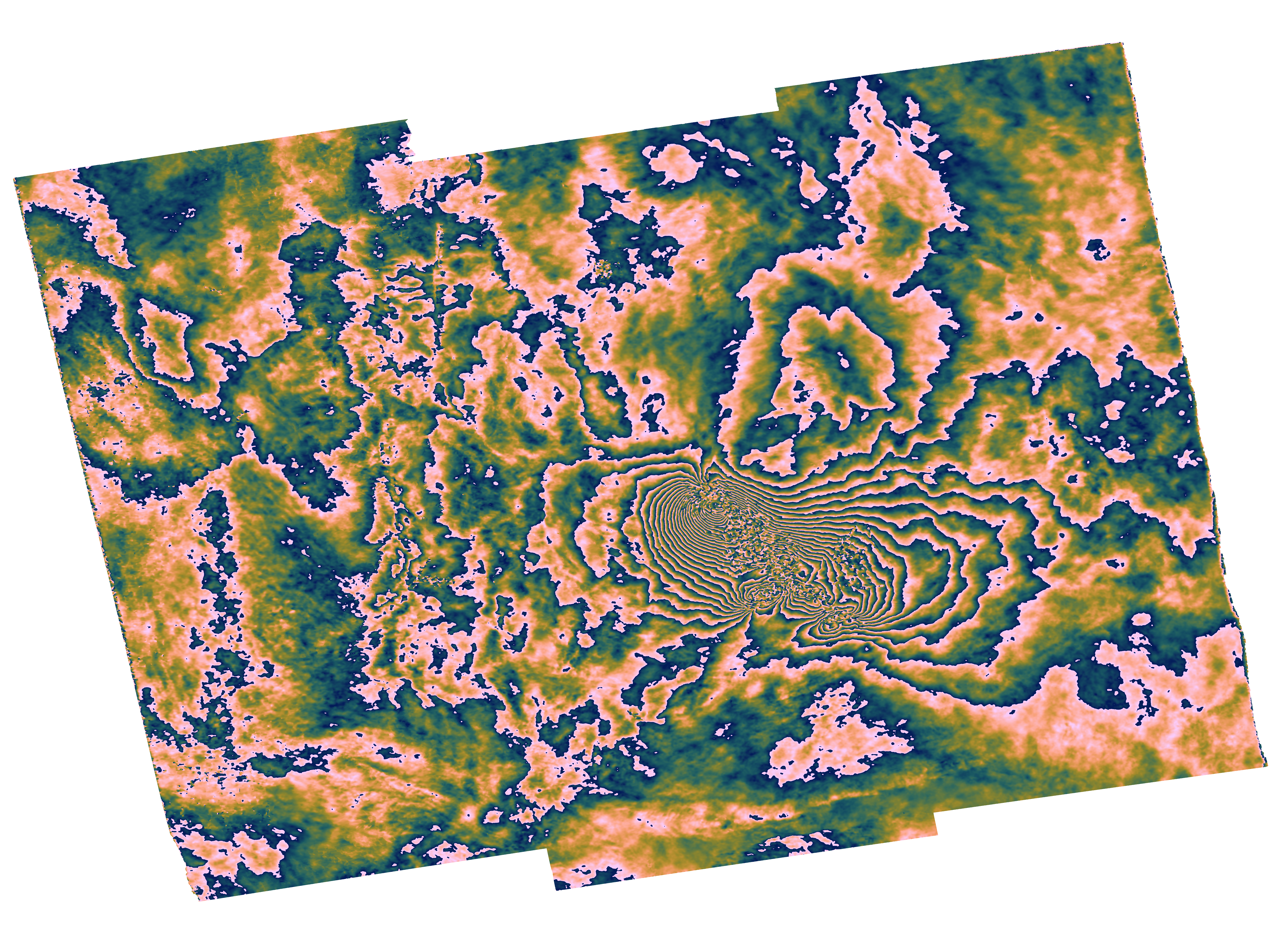
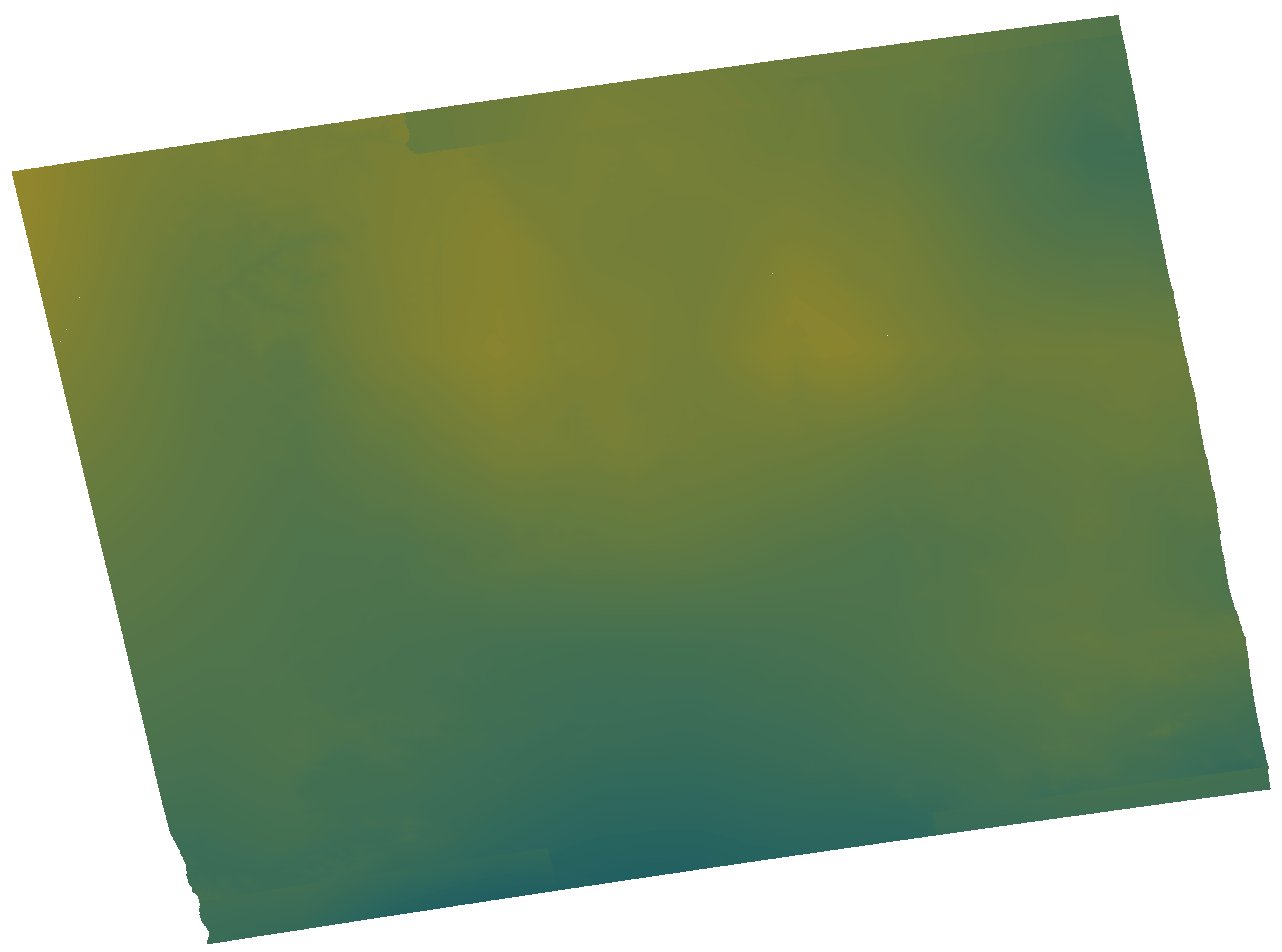
GDM-SAR-In Ridgcrest interférogramme 2019-07-04 à 2019-07-16

Ensemble d'interférogrammes différentiels, enroulés et déroulés, ainsi que les cartes de corrections atmosphériques utilisées et de cohérence spatiale.

Simple

Date (Révision)
2024-04-16
Identificateur
https://formater.osug.fr/permanent-products-repository/public/ebded694-da09-11ee-af92-0242c0a87004/#INTERFEROGRAM_20190704-20190716

Etat
Finalisé
Contact pour la ressource
Nom de l'organisation Nom de la personne Adresse e-mail Rôle
UGA

gdm-insar@poleterresolide.fr

Distributeur

FormaTerre

gdm-insar@poleterresolide.fr

Point de contact
Fréquence de mise à jour
Lorsque nécessaire
FormaTerre | Product Ontology
  • Interférogramme
FormaTerre | Distributor
  • UGA
Méthodes et solutions
  • GDM-SAR-In
FormaTerre | Feature Of Interest
  • Séisme
Relative Orbit Number
  • A064

FormaTerre | Platform Ontology
  • SENTINEL-1
FormaTerre | Solid Earth Discipline ontology
  • Déformation du sol
  • Tremblement de terre
Polarisation
  • VV

Localisation
  • Ridgcrest

Contraintes d'accès
Restreint
Contraintes d'utilisation
Autres restrictions
Contraintes d'utilisation
Licence
Autres contraintes
CC-BY-NC
Type de représentation spatiale
Raster
Distance de résolution
60  m
Langue de la ressource

eng

Encodage des caractères
Utf8
Catégorie ISO
  • Sciences de la terre, géosciences
N
S
E
W


Date de début
2019-07-04
Date de fin
2019-07-16
Nom du système de référence
WGS 1984
Format (encodage)
Nom Version

TIFF

Contact
Nom de l'organisation Nom de la personne Adresse e-mail Rôle

UGA

Ressource en ligne
Protocole Adresse Internet Nom

WWW:DOWNLOAD-1.0-http--download

https://formater.osug.fr/permanent-products-repository/public/ebded694-da09-11ee-af92-0242c0a87004/iw1_iw2_iw3/GDM_Coh_geo_20190704_20190716_4rlks.tiff

Coh_GDMCNRS_Coh_geo_20190704_20190716_7E3D

WWW:DOWNLOAD-1.0-http--download

https://formater.osug.fr/permanent-products-repository/public/ebded694-da09-11ee-af92-0242c0a87004/iw1_iw2_iw3/GDM_InU_geo_20190704_20190716_sd_era_4rlks.tiff

InU_GDMCNRS_InU_geo_20190704_20190716_5A42

WWW:DOWNLOAD-1.0-http--download

https://formater.osug.fr/permanent-products-repository/public/ebded694-da09-11ee-af92-0242c0a87004/iw1_iw2_iw3/GDM_InW_geo_20190704_20190716_sd_era_4rlks.tiff

InW_GDMCNRS_InW_geo_20190704_20190716_AF8A

WWW:DOWNLOAD-1.0-http--download

https://formater.osug.fr/permanent-products-repository/public/ebded694-da09-11ee-af92-0242c0a87004/iw1_iw2_iw3/GDM_InWF_geo_20190704_20190716_sd_era_4rlks.tiff

InWF_GDMCNRS_InWF_geo_20190704_20190716_CA30

WWW:DOWNLOAD-1.0-http--download

https://formater.osug.fr/permanent-products-repository/public/ebded694-da09-11ee-af92-0242c0a87004/iw1_iw2_iw3/GDM_APS_radar_20190704_20190716_4rlks.tiff

APS_GDMCNRS_APS_radar_20190704_20190716_B115

WWW:DOWNLOAD-1.0-http--download

https://formater.osug.fr/permanent-products-repository/public/ebded694-da09-11ee-af92-0242c0a87004/iw1_iw2_iw3/GDM_Coh_radar_20190704_20190716_4rlks.tiff

Coh_GDMCNRS_Coh_radar_20190704_20190716_0C83

WWW:DOWNLOAD-1.0-http--download

https://formater.osug.fr/permanent-products-repository/public/ebded694-da09-11ee-af92-0242c0a87004/iw1_iw2_iw3/GDM_InU_radar_20190704_20190716_sd_era_4rlks.tiff

InU_GDMCNRS_InU_radar_20190704_20190716_9D42

WWW:DOWNLOAD-1.0-http--download

https://formater.osug.fr/permanent-products-repository/public/ebded694-da09-11ee-af92-0242c0a87004/iw1_iw2_iw3/GDM_InW_radar_20190704_20190716_sd_era_4rlks.tiff

InW_GDMCNRS_InW_radar_20190704_20190716_1146

WWW:DOWNLOAD-1.0-http--download

https://formater.osug.fr/permanent-products-repository/public/ebded694-da09-11ee-af92-0242c0a87004/iw1_iw2_iw3/GDM_InWF_radar_20190704_20190716_sd_era_4rlks.tiff

InWF_GDMCNRS_InWF_radar_20190704_20190716_3A02

WWW:LINK-1.0-http--link

https://formater.pages.in2p3.fr/flatsim/interferogram.html

Documentation produit

WWW:DOWNLOAD-1.0-http--download

https://formater.osug.fr/permanent-products-repository/public/ebded694-da09-11ee-af92-0242c0a87004/iw1_iw2_iw3/GDM_APS_geo_20190704_20190716_4rlks.tiff

APS_GDMCNRS_APS_geo_20190704_20190716_B043

Niveau
Collection de données

Étendue

No information provided.
Généralités sur la provenance

Ces collections d'interférogrammes et de séries temporelles de déplacement sont produites par le CNES dans le cadre du service GDM-SAR-In. Ce service est développé en collaboration avec le pôle de Données et Services FormaTerre et les laboratoires ISTerre, LGL-TPE et IPGP. Les images radar utilisées proviennent de l’archive TOPSAR Sentinel-1 (données Copernicus). Les calculs sont faits à partir de la chaîne de traitement interférométrique NSBAS

Métadonnées

Identifiant de la fiche
8761aaa1-6cb9-4af8-b540-90bf047d024e XML
Langue
Français
Jeu de caractères
Utf8
Identifiant de la fiche de métadonnées parent
GDM-SAR-In Ridgcrest Collection d'interférogrammes et série temporelle 2019-05-17 à 2019-08-16

ebded694-da09-11ee-af92-0242c0a87004

Type de ressource
Collection de données
Date des métadonnées
2024-12-18T12:37:11
Nom du standard de métadonnées

ISO 19115:2003/19139

Version du standard de métadonnées

1.0

Contact
Nom de l'organisation Nom de la personne Adresse e-mail Rôle

FormaTerre

contact@poleterresolide.fr

Point de contact
Autre langue
LanguageCode CharacterEncoding
Anglais Utf8
Français Utf8


Aperçus

Coh_GDMCNRS_Coh_geo_20190704_20190716_7E3D
InU_GDMCNRS_InU_geo_20190704_20190716_5A42
InW_GDMCNRS_InW_geo_20190704_20190716_AF8A
InWF_GDMCNRS_InWF_geo_20190704_20190716_CA30
APS_GDMCNRS_APS_geo_20190704_20190716_B043

Étendue spatiale

N
S
E
W


Mots clés

FormaTerre | Distributor

UGA
FormaTerre | Feature Of Interest

Séisme
FormaTerre | Platform Ontology

SENTINEL-1
FormaTerre | Product Ontology

Interférogramme
FormaTerre | Solid Earth Discipline ontology

Déformation du sol Tremblement de terre
Méthodes et solutions

GDM-SAR-In
Polarisation

VV
Relative Orbit Number

A064


Fourni par

Lien vers le catalogue
Consultez l'intégralité des métadonnées et accédez à la donnée.


  •   À propos
  •   Github
  •