• Catalogue FormaTerre
  •   Search
  •   Map
  •  Sign in

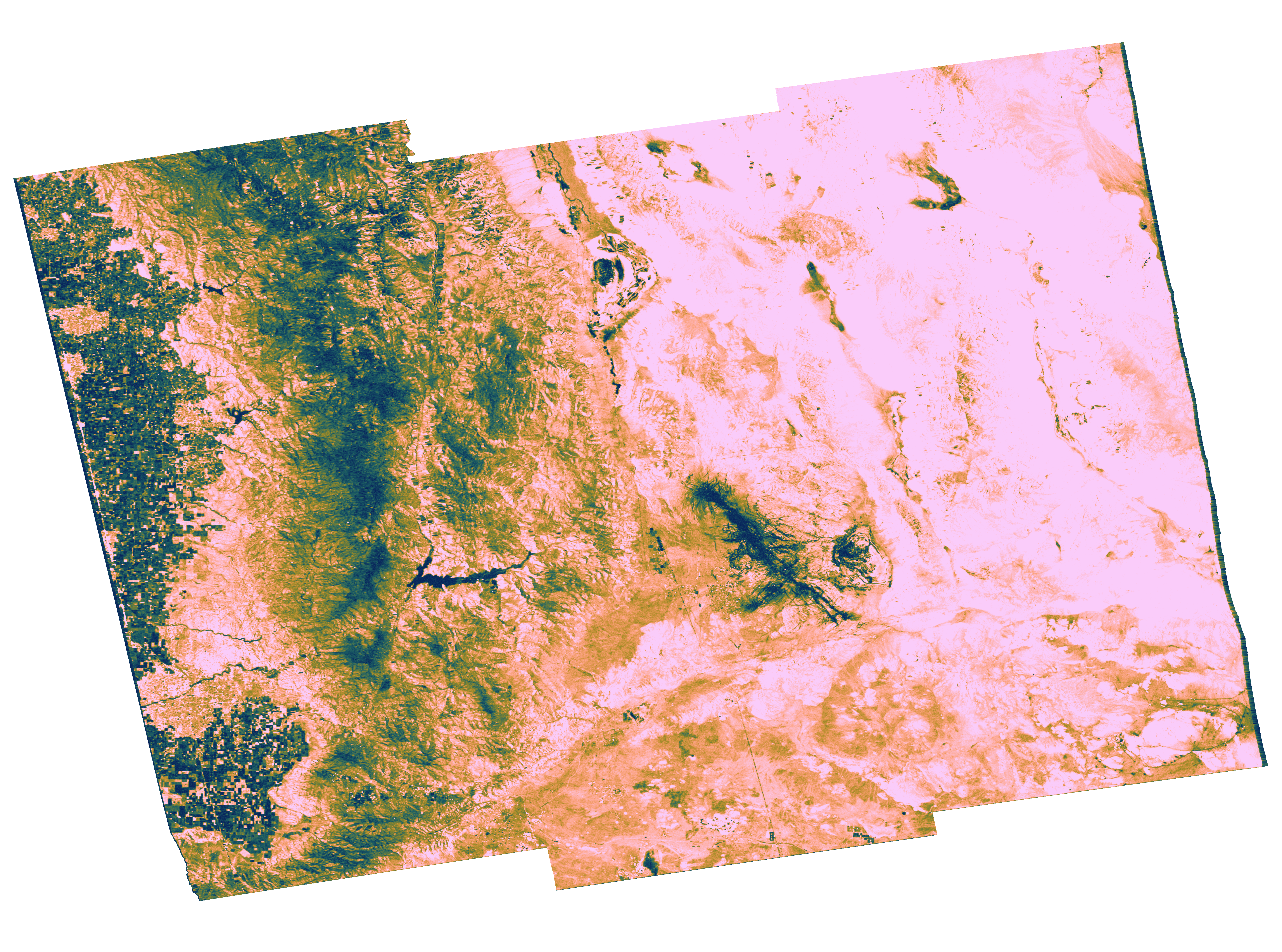
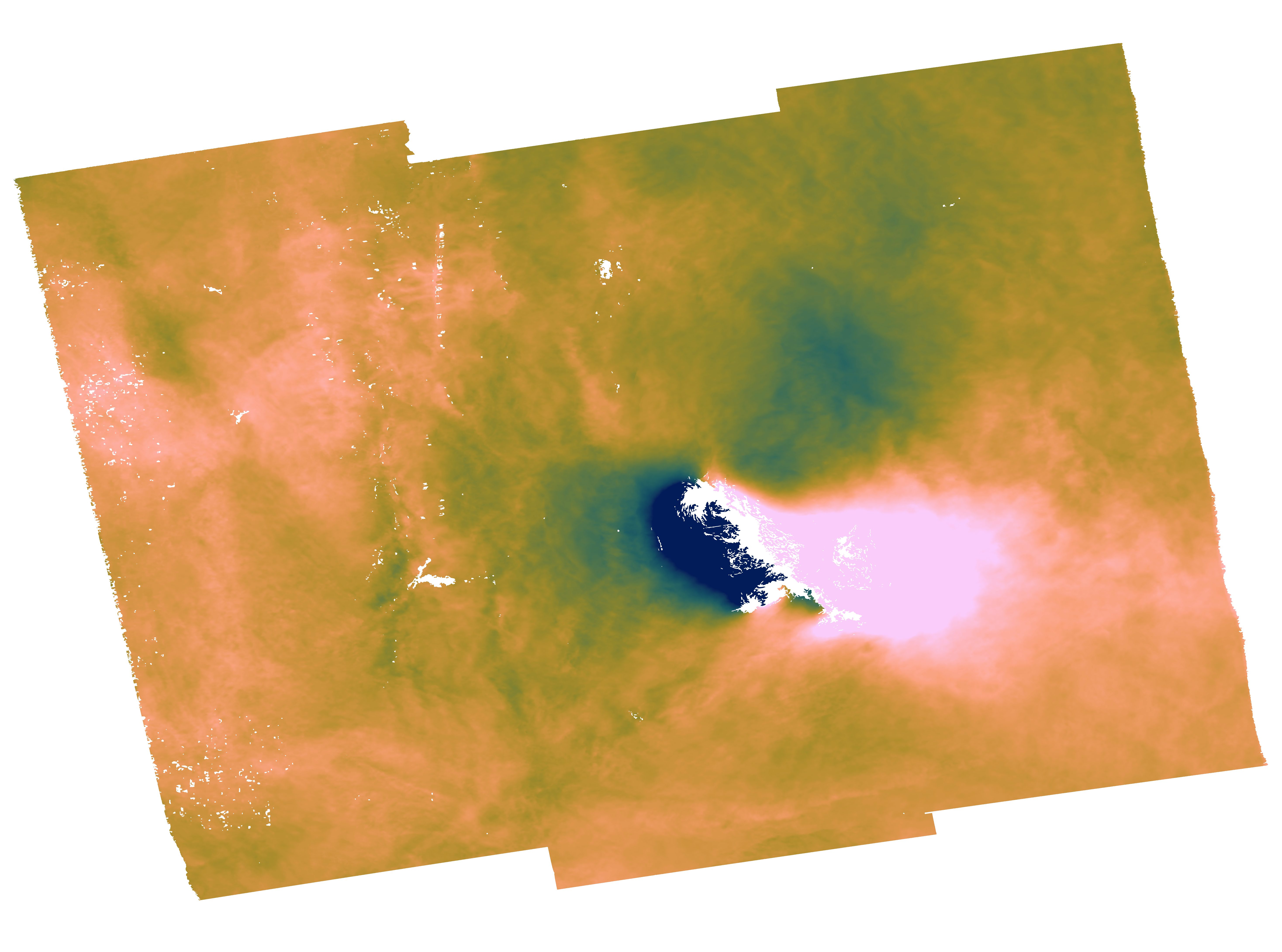
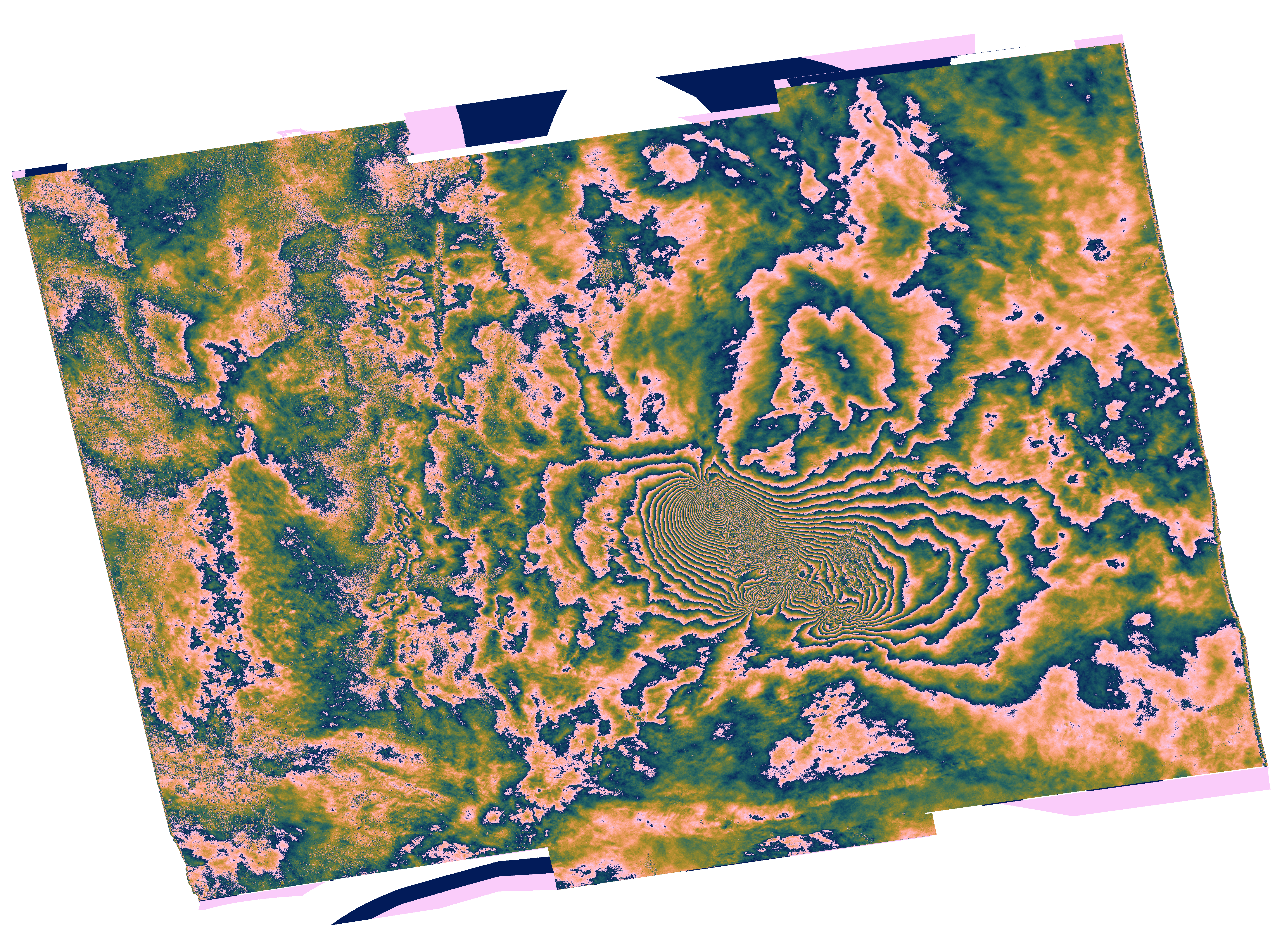
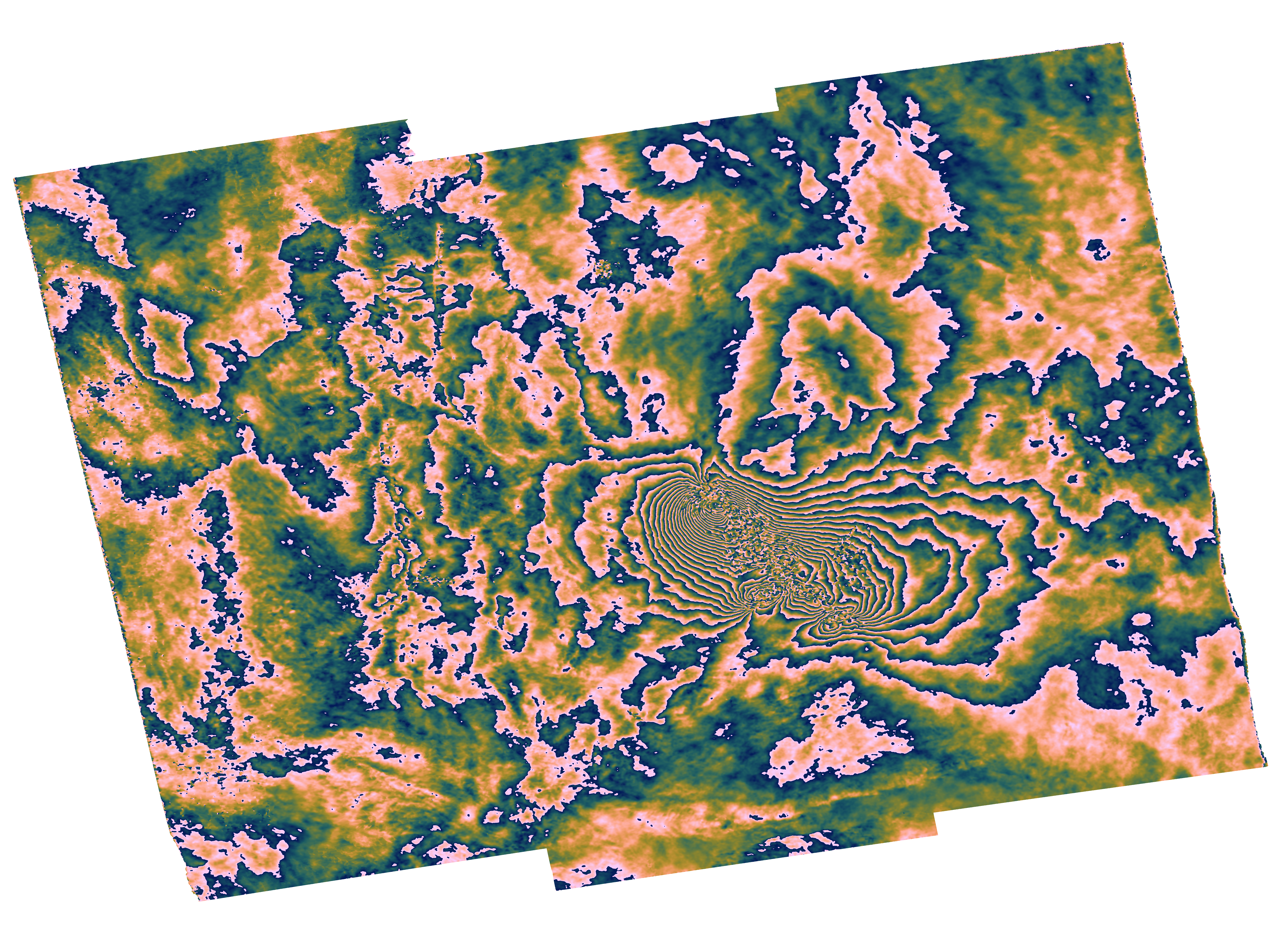
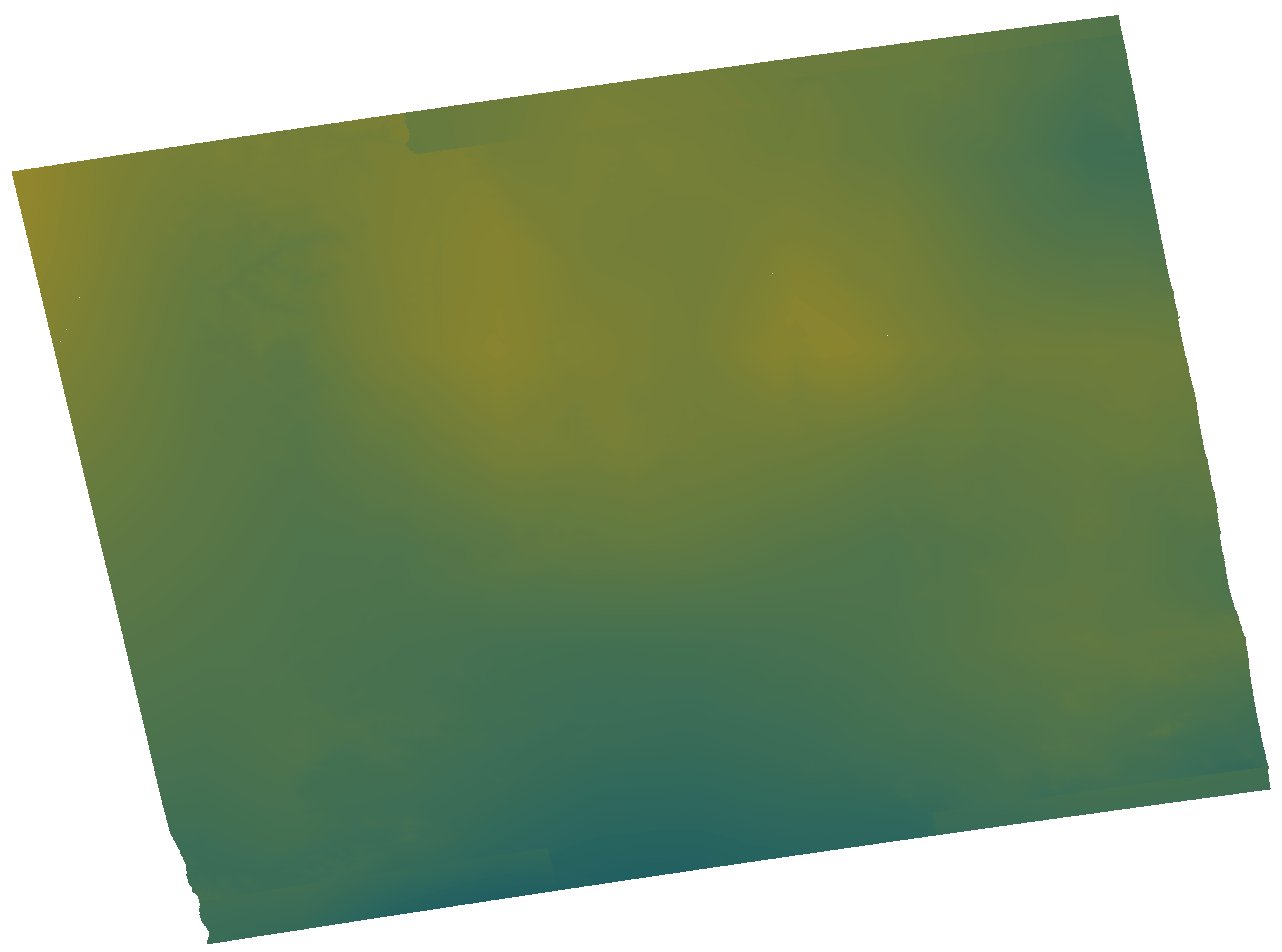
GDM-SAR-In Ridgcrest interferogram 2019-07-04 to 2019-07-16

This brings together the differential interferograms, wound and unwound, in radar or terrain geometry, filtered or not, at different resolutions, as well as the atmospheric correction maps used and spatial coherence.

Simple

Date (Revision)
2024-04-16
Citation identifier
https://formater.osug.fr/permanent-products-repository/public/ebded694-da09-11ee-af92-0242c0a87004/#INTERFEROGRAM_20190704-20190716

Status
Completed
Point of contact
Organisation name Individual name Electronic mail address Role
UGA

gdm-insar@poleterresolide.fr

Distributor

FormaTerre

gdm-insar@poleterresolide.fr

Point of contact
Maintenance and update frequency
As needed
FormaTerre | Product Ontology
  • Interferogram
FormaTerre | Distributor
  • UGA
Méthodes et solutions
  • GDM-SAR-In
FormaTerre | Feature Of Interest
  • Earthquake
Relative Orbit Number
  • A064

FormaTerre | Platform Ontology
  • SENTINEL-1
FormaTerre | Solid Earth Discipline ontology
  • Ground deformation
  • Earthquake
Polarisation
  • VV

Place
  • Ridgcrest

Access constraints
Restricted
Use constraints
Other restrictions
Use constraints
License
Other constraints
CC-BY-NC
Spatial representation type
Grid
Distance
60  m
Language

eng

Character set
UTF8
Topic category
  • Geoscientific information
N
S
E
W
thumbnail


Begin date
2019-07-04
End date
2019-07-16
Reference system identifier
WGS 1984
Distribution format
Name Version

TIFF

Distributor contact
Organisation name Individual name Electronic mail address Role

UGA

OnLine resource
Protocol Linkage Name

WWW:DOWNLOAD-1.0-http--download

https://formater.osug.fr/permanent-products-repository/public/ebded694-da09-11ee-af92-0242c0a87004/iw1_iw2_iw3/GDM_Coh_geo_20190704_20190716_4rlks.tiff

Coh_GDMCNRS_Coh_geo_20190704_20190716_7E3D

WWW:DOWNLOAD-1.0-http--download

https://formater.osug.fr/permanent-products-repository/public/ebded694-da09-11ee-af92-0242c0a87004/iw1_iw2_iw3/GDM_InU_geo_20190704_20190716_sd_era_4rlks.tiff

InU_GDMCNRS_InU_geo_20190704_20190716_5A42

WWW:DOWNLOAD-1.0-http--download

https://formater.osug.fr/permanent-products-repository/public/ebded694-da09-11ee-af92-0242c0a87004/iw1_iw2_iw3/GDM_InW_geo_20190704_20190716_sd_era_4rlks.tiff

InW_GDMCNRS_InW_geo_20190704_20190716_AF8A

WWW:DOWNLOAD-1.0-http--download

https://formater.osug.fr/permanent-products-repository/public/ebded694-da09-11ee-af92-0242c0a87004/iw1_iw2_iw3/GDM_InWF_geo_20190704_20190716_sd_era_4rlks.tiff

InWF_GDMCNRS_InWF_geo_20190704_20190716_CA30

WWW:DOWNLOAD-1.0-http--download

https://formater.osug.fr/permanent-products-repository/public/ebded694-da09-11ee-af92-0242c0a87004/iw1_iw2_iw3/GDM_APS_radar_20190704_20190716_4rlks.tiff

APS_GDMCNRS_APS_radar_20190704_20190716_B115

WWW:DOWNLOAD-1.0-http--download

https://formater.osug.fr/permanent-products-repository/public/ebded694-da09-11ee-af92-0242c0a87004/iw1_iw2_iw3/GDM_Coh_radar_20190704_20190716_4rlks.tiff

Coh_GDMCNRS_Coh_radar_20190704_20190716_0C83

WWW:DOWNLOAD-1.0-http--download

https://formater.osug.fr/permanent-products-repository/public/ebded694-da09-11ee-af92-0242c0a87004/iw1_iw2_iw3/GDM_InU_radar_20190704_20190716_sd_era_4rlks.tiff

InU_GDMCNRS_InU_radar_20190704_20190716_9D42

WWW:DOWNLOAD-1.0-http--download

https://formater.osug.fr/permanent-products-repository/public/ebded694-da09-11ee-af92-0242c0a87004/iw1_iw2_iw3/GDM_InW_radar_20190704_20190716_sd_era_4rlks.tiff

InW_GDMCNRS_InW_radar_20190704_20190716_1146

WWW:DOWNLOAD-1.0-http--download

https://formater.osug.fr/permanent-products-repository/public/ebded694-da09-11ee-af92-0242c0a87004/iw1_iw2_iw3/GDM_InWF_radar_20190704_20190716_sd_era_4rlks.tiff

InWF_GDMCNRS_InWF_radar_20190704_20190716_3A02

WWW:LINK-1.0-http--link

https://formater.pages.in2p3.fr/flatsim/interferogram.html

Product documentation

WWW:DOWNLOAD-1.0-http--download

https://formater.osug.fr/permanent-products-repository/public/ebded694-da09-11ee-af92-0242c0a87004/iw1_iw2_iw3/GDM_APS_geo_20190704_20190716_4rlks.tiff

APS_GDMCNRS_APS_geo_20190704_20190716_B043

Hierarchy level
Series

Extent

No information provided.
Statement

These collections of interferograms and displacement time series are produced by CNES as part of the GDM-SAR-In service. This service is developed in collaboration with the ForM @ Ter Data and Services pole and the ISTerre, LGL-TPE and IPGP laboratories. The radar images used come from the TOPSAR Sentinel-1 archive (Copernicus data). The calculations are made from the NSBAS interferometric processing chain

Metadata

File identifier
8761aaa1-6cb9-4af8-b540-90bf047d024e XML
Metadata language
Français
Character set
UTF8
Parent identifier
GDM-SAR-In Ridgcrest Collection d'interférogrammes et série temporelle 2019-05-17 à 2019-08-16

ebded694-da09-11ee-af92-0242c0a87004

Hierarchy level
Series
Date stamp
2024-12-18T12:37:11
Metadata standard name

ISO 19115:2003/19139

Metadata standard version

1.0

Metadata author
Organisation name Individual name Electronic mail address Role

FormaTerre

contact@poleterresolide.fr

Point of contact
Other language
Language Character encoding
English UTF8
French UTF8


Overviews

overview
Coh_GDMCNRS_Coh_geo_20190704_20190716_7E3D
overview
InU_GDMCNRS_InU_geo_20190704_20190716_5A42
overview
InW_GDMCNRS_InW_geo_20190704_20190716_AF8A
overview
InWF_GDMCNRS_InWF_geo_20190704_20190716_CA30
overview
APS_GDMCNRS_APS_geo_20190704_20190716_B043

Spatial extent

N
S
E
W
thumbnail


Keywords

FormaTerre | Distributor

UGA
FormaTerre | Feature Of Interest

Earthquake
FormaTerre | Platform Ontology

SENTINEL-1
FormaTerre | Product Ontology

Interferogram
FormaTerre | Solid Earth Discipline ontology

Earthquake Ground deformation
Méthodes et solutions

GDM-SAR-In
Polarisation

VV
Relative Orbit Number

A064


Provided by

logo
Access to the catalogue
Read here the full details and access to the data.


  •   About
  •   Github
  •