Collection d'interférogrammes et séries temporelles Sentinel-1 sur l'aquifère d'Ozark 2014-2021
Sentinel-1 Interferograms and time series collection on Ozark aquifer 2014-2021
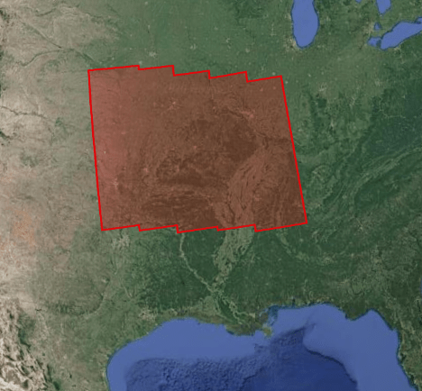
Ce projet se focalise sur l’étude des déformations associées à l’aquifère d’Ozark (sud du bassin du Mississipi) soumis à de fortes variations de niveau d’eaux souterraines, et dans les régions voisines où une sismicité importante est observée, à forte composante saisonnière (New Madrid), ou liée à des injections d’eaux usées (Oklahoma). L’objectif est de mieux comprendre la signature géodésique du cycle hydrologique.
Trois types de produits sont mis à disposition pour chaque portion d’orbite traitée (voir la <a href=" https://formater.pages.in2p3.fr/flatsim/" target="_blank">description détaillée</a>)
- « INTERFEROGRAM » : ensemble d'interférogrammes différentiels, enroulés et déroulés, en géométrie radar ou terrain, filtrés ou non, à différentes résolutions, ainsi que les cartes de corrections atmosphériques utilisées et de cohérence spatiale pour chaque interférogramme.
- « TIMESERIES » : répertoire incluant des cartes de déplacement en série temporelle et de vitesse moyenne, selon la ligne de visée du satellite (LOS), et des indices qualité du traitement en série temporelle.
- « AUXILIARYDATA » : ce repertoire contient des cartes indiquant le vecteur LOS, le MNT en géométrie radar, à différentes résolutions, les tables de transcodage géométrie radar-terrain, et la cohérence temporelle, ainsi qu’un ensemble de figures et fichiers de paramètres spécifiques au traitement de la série temporelle.
This project focuses on the study of the deformations associated with the Ozark aquifer (south of the Mississippi basin) subjected to strong variations in groundwater level, and in neighboring regions where significant seismicity is observed, at strong seasonal component (New Madrid), or linked to wastewater injections (Oklahoma). The objective is to better understand the geodesic signature of the hydrological cycle.
Three types of products are made available for each orbit portion processed (see <a href=" https://formater.pages.in2p3.fr/flatsim/" target="_blank"> detailed description </a> )
- "INTERFEROGRAM": this brings together the differential interferograms, wound and unwound, in radar or terrain geometry, filtered or not, at different resolutions, as well as the atmospheric correction maps used and spatial coherence for each interferogram.
- "TIMESERIES": this includes maps of movement in time series and average speed, according to the satellite line of sight (LOS), and quality indices of time series processing.
- "AUXILIARYDATA": this directory contains maps indicating the LOS vector, the DTM in radar geometry, at different resolutions, the radar-field geometry transcoding tables, and temporal coherence, as well as a set of figures and parameter files specific to the processing of the time series.
Simple
-
Date (Publication)Date (Publication)
- 2021-10-11
-
Citation identifierIdentificateur
- urn:ogc:def:EOP:CNES::OZARK:
-
ButPurpose
-
Ce projet se focalise sur l’étude des déformations associées à l’aquifère d’Ozark (sud du bassin du Mississipi) soumis à de fortes variations de niveau d’eaux souterraines, et dans les régions voisines où une sismicité importante est observée, à forte composante saisonnière (New Madrid), ou liée à des injections d’eaux usées (Oklahoma). L’objectif est de mieux comprendre la signature géodésique du cycle hydrologique.
This project focuses on the study of the deformations associated with the Ozark aquifer (south of the Mississippi basin) subjected to strong variations in groundwater level, and in neighboring regions where significant seismicity is observed, at strong seasonal component (New Madrid), or linked to wastewater injections (Oklahoma). The objective is to better understand the geodesic signature of the hydrological cycle.
-
StatusEtat
-
CompletedFinalisé
- Point of contact
-
Organisation name Individual name Electronic mail address Role CNESCNESDistributorDistributeurFormaTerre
FormaTerre
Point of contactPoint de contact
-
Maintenance and update frequencyFréquence de mise à jour
-
As neededLorsque nécessaire
-
ThemeThème
-
-
InSar
InSar
-
Déformation
Deformation
-
Interférogramme
interferogram
-
Hydrologie
Hydrology
-
-
locationlocation
-
-
Ozark
Ozark
-
-
Access constraintsContraintes d'accès
-
RestrictedRestreint
-
Use constraintsContraintes d'utilisation
-
Other restrictionsAutres restrictions
-
Use constraintsContraintes d'utilisation
-
LicenseLicence
-
Autres contraintesOther constraints
-
Comment citer les produits: "FormaTerre (2020): FLATSIM Data Products. CNES. (Dataset), doi: https://www.doi.org/10.24400/253171/FLATSIM2020 "
How to cite: "FormaTerre (2020): FLATSIM Data Products. CNES. (Dataset), doi: https://www.doi.org/10.24400/253171/FLATSIM2020 "
-
Autres contraintesOther constraints
-
Autres contraintesOther constraints
-
Données FAIR, en phase de validation, accessibles uniquement à la communauté FormaTerre.
FAIR data, in validation phase, accessible only to the FormaTerre community
-
Spatial representation typeType de représentation spatiale
-
GridRaster
-
DistanceDistance de résolution
- 320 m
- Language
-
eng
-
Character setEncodage des caractères
-
UTF8Utf8
-
Topic categoryCatégorie ISO
-
-
Geoscientific informationSciences de la terre, géosciences
-
))
- Begin date
- 2014-10-01
- End date
- 2021-05-01
-
Reference system identifierNom du système de référence
-
WGS 1984WGS 1984
- Distribution format
-
Name Version TIFF
GEOTIFF
CSV
CSV
- Distributor contact
-
Organisation name Individual name Electronic mail address Role CNESCNES
- OnLine resource
-
Protocol Linkage Name DOI
https://doi.org/10.24400/253171/FLATSIM2020 DOI 10.24400/253171/FLATSIM2020
DOI 10.24400/253171/FLATSIM2020
WWW:LINK-1.0-http--related
https://www.mdpi.com/2072-4292/13/18/3734/htm Thollard & al. 2021
Thollard & al. 2021
WWW:LINK-1.0-http--related
http://proceedings.esa.int/files/116.pdf Grandin. 2015
Grandin. 2015
WWW:LINK-1.0-http--related
https://flatsim.poleterresolide.fr/docs/NSBAS_Etna.pdf Doin & al. 2011
Doin & al. 2011
WWW:LINK-1.0-http--samples
https://formater.pages.in2p3.fr/flatsim/ Documentation Produits
Product documentation
STAC
https://geodes-portal.cnes.fr/api/stac/search?search=free&view=FLATSIM_OZARK_VD&download=FLATSIM_OZARK_VD&dataset=FLATSIM_INTERFEROGRAM,FLATSIM_TIMESERIE,FLATSIM_AUXILIARYDATA&grid:code=OZARK API STAC
API STAC
-
Hierarchy levelNiveau
-
SeriesCollection de données
Extent
Étendue
-
Généralités sur la provenanceStatement
-
Ces collections d'interférogrammes et de séries temporelles de déplacement sont produites par le CNES dans le cadre du service FLATSIM. Ce service est développé en collaboration avec le pôle de Données et Services FormaTerre et les laboratoires ISTerre, LGL-TPE et IPGP. Les images radar utilisées proviennent de l’archive TOPSAR Sentinel-1 (données Copernicus). Les calculs sont faits à partir de la chaîne de traitement interférométrique NSBAS
These collections of interferograms and displacement time series are produced by CNES as part of the FLATSIM service. This service is developed in collaboration with the ForM @ Ter Data and Services pole and the ISTerre, LGL-TPE and IPGP laboratories. The radar images used come from the TOPSAR Sentinel-1 archive (Copernicus data). The calculations are made from the NSBAS interferometric processing chain
Metadata
-
File identifierIdentifiant de la fiche
- 4d79a6b6-57e6-466f-b196-04d7fd93a641 XML
-
Metadata languageLangue
- Français
-
Character setJeu de caractères
-
UTF8Utf8
-
Hierarchy levelType de ressource
-
SeriesCollection de données
-
Date stampDate des métadonnées
- 2026-03-12T11:52:59.463Z
- Metadata standard name
-
ISO 19115:2003/19139
- Metadata standard version
-
1.0
- Metadata author
-
Organisation name Individual name Electronic mail address Role FormaTerre
FormaTerre
Point of contactPoint de contact
- Other language
-
Language Character encoding EnglishAnglaisUTF8Utf8FrenchFrançaisUTF8Utf8
Overviews
Spatial extent
Provided by
