Catalogue FormaTerre
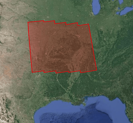
Sentinel-1 Interferograms and time series collection on Ozark aquifer 2014-2021
This project focuses on the study of the deformations associated with the Ozark aquifer (south of the Mississippi basin) subjected to strong variations in groundwater level, and in neighboring regions where significant seismicity is observed, at strong seasonal component (New Madrid), or linked to wastewater injections (Oklahoma). The objective is to better understand the geodesic signature of the hydrological cycle.
Three types of products are made available for each orbit portion processed (see <a href=" https://formater.pages.in2p3.fr/flatsim/" target="_blank"> detailed description </a> )
- "INTERFEROGRAM": this brings together the differential interferograms, wound and unwound, in radar or terrain geometry, filtered or not, at different resolutions, as well as the atmospheric correction maps used and spatial coherence for each interferogram.
- "TIMESERIES": this includes maps of movement in time series and average speed, according to the satellite line of sight (LOS), and quality indices of time series processing.
- "AUXILIARYDATA": this directory contains maps indicating the LOS vector, the DTM in radar geometry, at different resolutions, the radar-field geometry transcoding tables, and temporal coherence, as well as a set of figures and parameter files specific to the processing of the time series.
Simple
- Date (Publication)
- 2021-10-11
- Citation identifier
- urn:ogc:def:EOP:CNES::OZARK:
- Purpose
-
This project focuses on the study of the deformations associated with the Ozark aquifer (south of the Mississippi basin) subjected to strong variations in groundwater level, and in neighboring regions where significant seismicity is observed, at strong seasonal component (New Madrid), or linked to wastewater injections (Oklahoma). The objective is to better understand the geodesic signature of the hydrological cycle.
- Status
- Completed
- Point of contact
-
Organisation name Individual name Electronic mail address Role CNES Distributor FormaTerre
Point of contact
- Maintenance and update frequency
- As needed
- Theme
-
-
InSar
-
Deformation
-
interferogram
-
Hydrology
-
- location
-
-
Ozark
-
- Access constraints
- Restricted
- Use constraints
- Other restrictions
- Use constraints
- License
- Other constraints
-
How to cite: "FormaTerre (2020): FLATSIM Data Products. CNES. (Dataset), doi: https://www.doi.org/10.24400/253171/FLATSIM2020 "
- Other constraints
- Other constraints
-
FAIR data, in validation phase, accessible only to the FormaTerre community
- Spatial representation type
- Grid
- Distance
- 320 m
- Language
-
eng
- Character set
- UTF8
- Topic category
-
- Geoscientific information
))
- Begin date
- 2014-10-01
- End date
- 2021-05-01
- Reference system identifier
- WGS 1984
- Distribution format
-
Name Version GEOTIFF
CSV
- Distributor contact
-
Organisation name Individual name Electronic mail address Role CNES
- OnLine resource
-
Protocol Linkage Name DOI
https://doi.org/10.24400/253171/FLATSIM2020 DOI 10.24400/253171/FLATSIM2020
WWW:LINK-1.0-http--related
https://www.mdpi.com/2072-4292/13/18/3734/htm Thollard & al. 2021
WWW:LINK-1.0-http--related
http://proceedings.esa.int/files/116.pdf Grandin. 2015
WWW:LINK-1.0-http--related
https://flatsim.poleterresolide.fr/docs/NSBAS_Etna.pdf Doin & al. 2011
WWW:LINK-1.0-http--samples
https://formater.pages.in2p3.fr/flatsim/ Product documentation
STAC
https://geodes-portal.cnes.fr/api/stac/search?search=free&view=FLATSIM_OZARK_VD&download=FLATSIM_OZARK_VD&dataset=FLATSIM_INTERFEROGRAM,FLATSIM_TIMESERIE,FLATSIM_AUXILIARYDATA&grid:code=OZARK API STAC
- Hierarchy level
- Series
Extent
- Statement
-
These collections of interferograms and displacement time series are produced by CNES as part of the FLATSIM service. This service is developed in collaboration with the ForM @ Ter Data and Services pole and the ISTerre, LGL-TPE and IPGP laboratories. The radar images used come from the TOPSAR Sentinel-1 archive (Copernicus data). The calculations are made from the NSBAS interferometric processing chain
Metadata
- File identifier
- 4d79a6b6-57e6-466f-b196-04d7fd93a641 XML
- Metadata language
- Français
- Character set
- UTF8
- Hierarchy level
- Series
- Date stamp
- 2026-03-12T11:52:59.463Z
- Metadata standard name
-
ISO 19115:2003/19139
- Metadata standard version
-
1.0
- Metadata author
-
Organisation name Individual name Electronic mail address Role FormaTerre
Point of contact
- Other language
-
Language Character encoding English UTF8 French UTF8